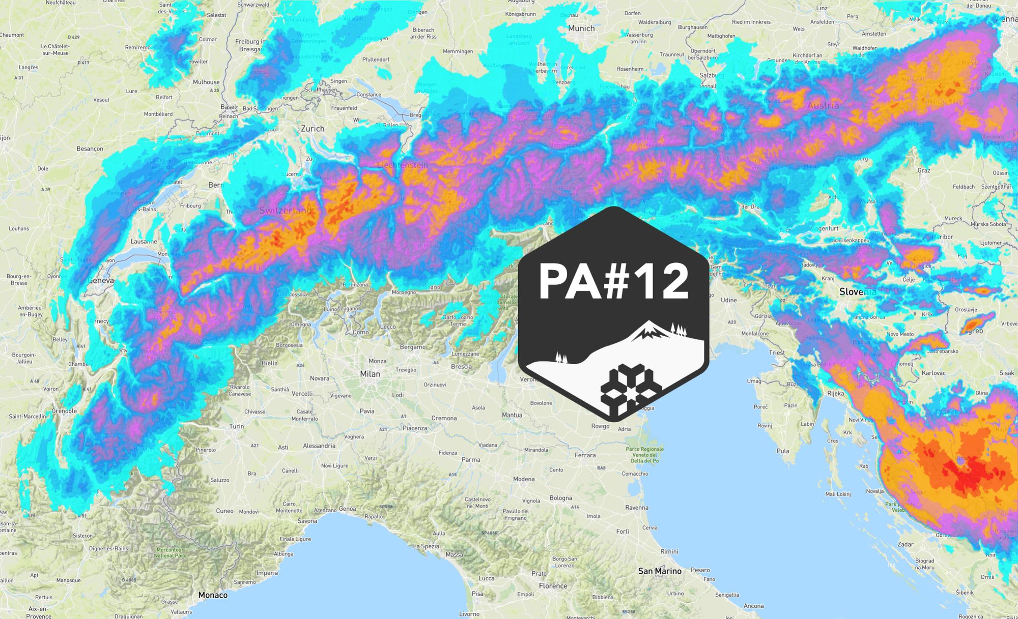
Finally, a Nordstau! Chris released PA#12 yesterday and that report also forms the basis for this update. Haven’t read it yet? Make sure to check that article first. Today we’ll give a short day-by-day overview and take a closer look at the model differences for Friday, as the latest runs now suggest less snow for Austria.

Short synoptic overview
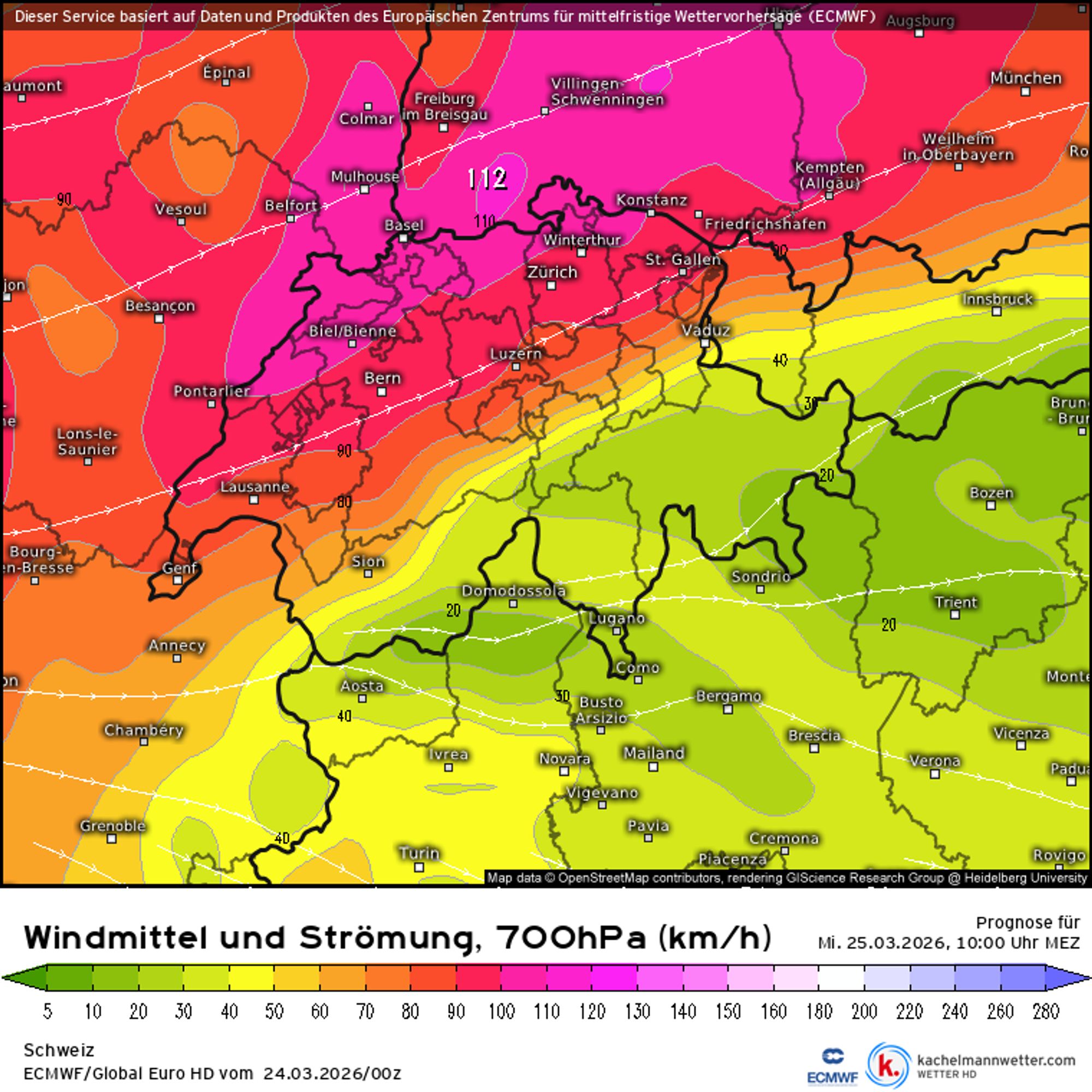
In three slides I outline the synoptic setup driving this snowfall. Between a blocking high over the Atlantic and a low over Scandinavia, a classic “conveyor belt” sets up from Wednesday onwards, pushing moist air straight into the Northern Alps. A well-defined cold front kicks off this snowfall phase on Wednesday afternoon. Snow levels will drop quickly to around 1000 meters and later further down towards 500 meters, while westerly to northwesterly winds increase significantly. The map below shows wind speeds exceeding 100 km/h at 3000 meters along the northern Alpine edge. In the high alpine and exposed terrain, gusts can be even stronger, locally up to 150 km/h. This may lead to lift closures during the day on Wednesday.
Thursday
Thursday will be the first real powder day in the Northern Alps. The morning already starts with a solid base of fresh snow in the northern French Alps, Switzerland and Vorarlberg, where around 20 to 40 cm will have fallen. In the Swiss stau regions, locally even more is possible. Further east in Austria, totals will initially be somewhat lower (10-20 cm), but more snow will fall during the day. Temperatures remain nicely cold, with snow levels reaching into most valleys. The southern side remains largely in the lee, aside from some temporary snowfall during Wednesday’s cold front passage. Higher up, visibility will be poor in the Northern Alps due to intense snowfall combined with strong winds.
Friday
Snow continues steadily on the northern side into Friday morning, adding another 10 to 30 cm (locally more) since Thursday morning. You can easily check these 24-hour totals in our forecast. Friday daytime remains a point of attention. The models are not fully aligned here, and compared to yesterday there are clear shifts. This fits with this type of low-pressure system, the so-called Adriatic lows, which are often difficult to pin down several days in advance. Patience is key in these setups, but here’s what we’re seeing:
High pressure starts to build in from the west on Friday, suppressing snowfall and allowing for clearing conditions. In eastern Austria, wrap-around precipitation from the low could keep snow falling longer, but these amounts are highly uncertain. Yesterday, several models hinted at total accumulations of up to a meter in areas like Hochkar due to heavy snowfall on Friday, but today the EC (main run), GFS and ICON are much more conservative. The low is now forecast further away from the Alps, limiting its impact.
So don’t count too much on those extreme totals. It’s better to stay in the core zone of the northern Alps, from France and Switzerland to Austria, roughly between Haute-Savoie/Valais/Berner Oberland and Salzburgerland. Our earlier tip to head further east in Austria (east of Salzburgerland) for very deep powder is therefore no longer valid, although we’ll keep monitoring the situation closely. Fortunately, there are still plenty of options at the end of March across the northern Alps that will definitely pick up significant snow. With continued cold air advection, temperatures remain fairly low through the weekend on the northern side, although a gradual warming on Friday and Saturday is expected to happen.
- 0-2 bft
- 3-5 bft
- 6 bft
- 7 bft
- 8 bft
- 9 bft
- 10 bft
- 11 bft
- 12 bft
Wind
As mentioned earlier, winds spike during the cold front passage, but they remain strong throughout the snowfall period. Not only on the northern side, but also due to the influx of much colder air especially in the inner-alpine regions and on the southern side in the form of Nordföhn. The Nordföhn strengthens Wednesday evening and persists through the weekend, although it weakens from the west on Friday. Thursday will be the day with the biggest impact on the southern side, with gusts well over 100 km/h at higher elevations. On the northern side, winds also remain strong during the Nordstau snowfall, especially on Thursday. The combination of large snowfall amounts and strong winds will increase avalanche danger, so make sure to check the latest avalanche bulletin before heading out.
Replies
Quick question, I’m never sure if Courmayeur is included in the North Alps discussion…same with Cervinia on the Zermatt side. I was thinking of heading to one of them on Thursday and Friday. Your perspective is highly appreciated.