Coen already clearly explained yesterday what we can expect this week. After a solid PowderAlert 12, it’s now time for PowderAlert 13, once again bringing snow from the north.

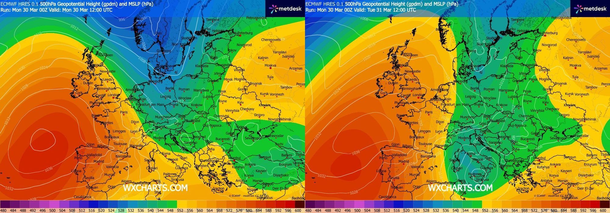
Weather maps at around 5 km altitude for Monday (left) and Tuesday (right) (wxcharts)
Brief synoptic overview
The snowfall is made possible by a well-defined upper-level trough (the wave with green/blue colors) visible on the map above. A pocket of cold air detaches from the main flow and moves southward. Over the Mediterranean, it develops into a storm depression with potentially severe weather in many places. During this southward movement, however, a northerly flow of moist air toward the Alps develops. Orographic lift gives an extra boost, resulting in significant snowfall once again.
We are already underway, as the first showers were pushed up against the northern Alps during the morning. Below is an animation of snowfall from Monday through Wednesday based on this morning’s ECMWF main run.
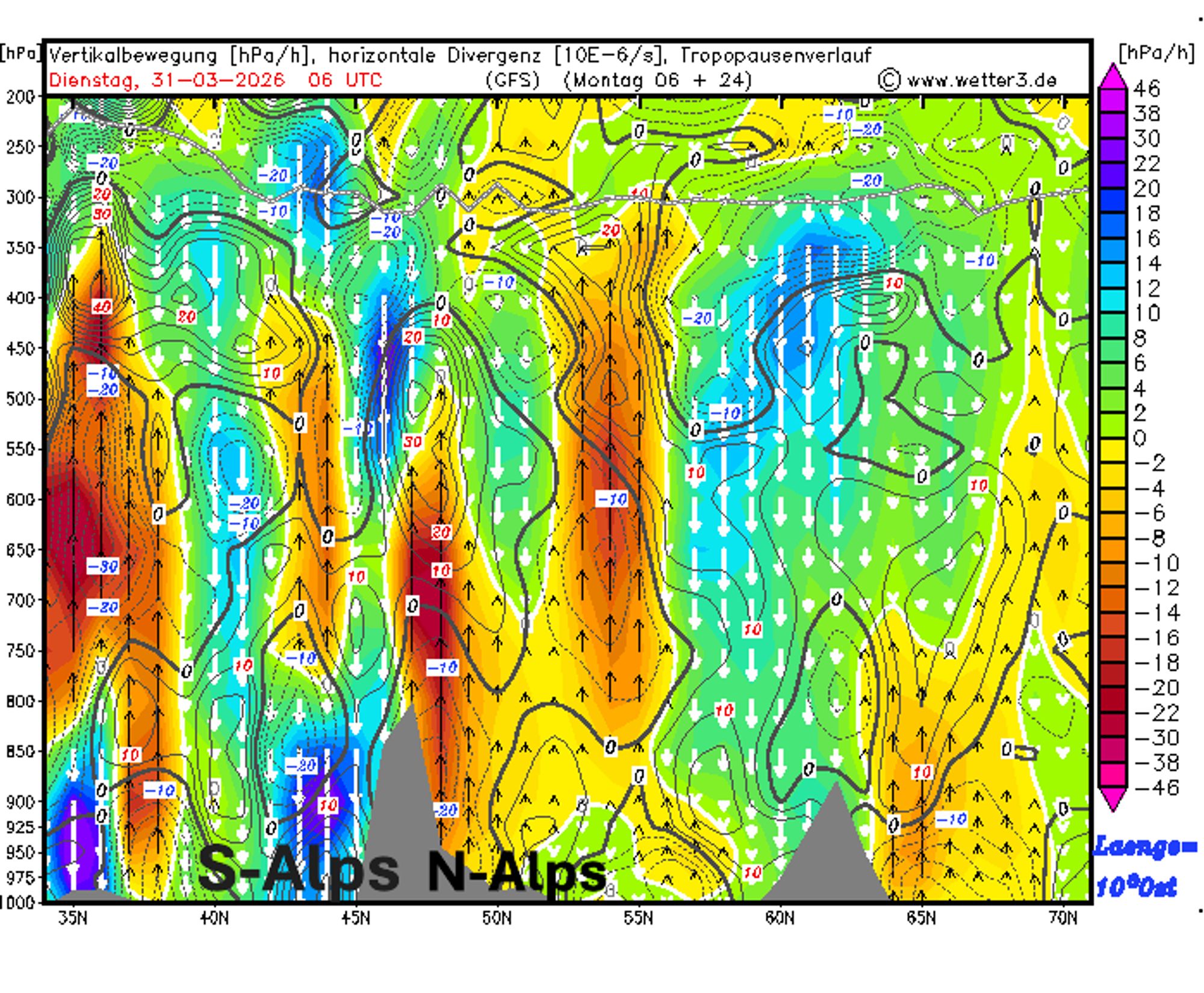
We can immediately see that the first phase of snowfall, from Monday to Tuesday afternoon, is the most intense. From Tuesday afternoon through Wednesday, it’s mainly residual showers being pushed against the Alps. The southern side remains dry due to descending air (Nordföhn). This orographic lifting is also clearly visible in this GFS cross-section along 10°E (Vorarlberg-Lombardy) for Tuesday morning, where the strong upward motion over the northern Alps stands out, while strong subsidence on the southern side is visible up to high altitudes.
What has already fallen?
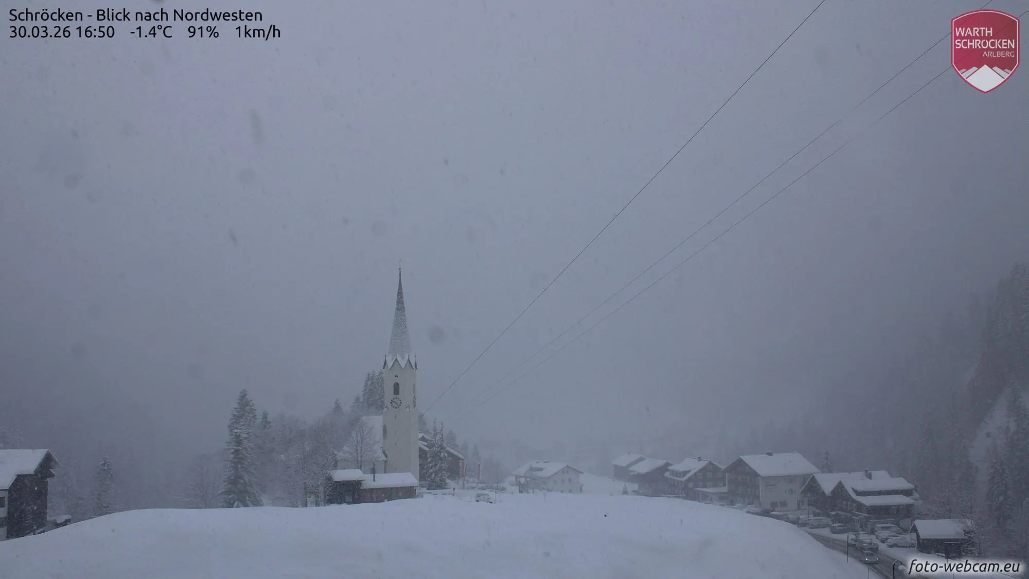
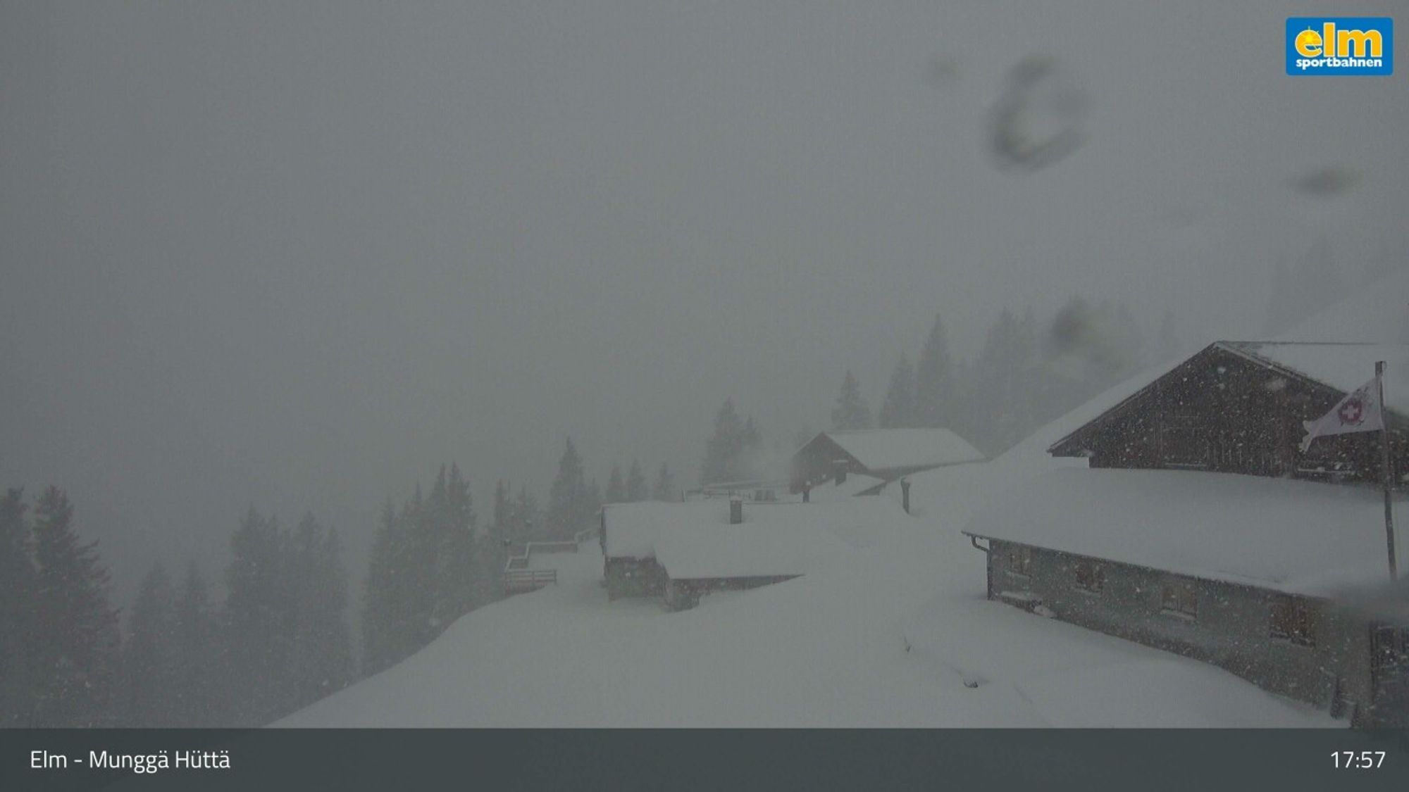
In a zone from central to eastern Switzerland, around 20-30 cm has already fallen. In many other places, totals are currently 10-20 cm, but more is on the way. The Glarus Alps, one of the typical hotspots during a northerly stau, are already locally above that, for example in Elm. The snowline is generally below 1000 meters and regionally around 500 meters, so quite low. Our forecast map clearly shows more to come, while also highlighting the hotspot from central Switzerland to Vorarlberg. Further west and east, less will fall (but still a decent amount!).

- 1cm
- 5cm
- 10cm
- 15cm
- 20cm
- 30cm
- 40cm
- 50cm
- 75cm
- 100+
- 1mm
- 5mm
- 10mm
- 20mm
- 30mm
- 60mm
- 120+
By Tuesday morning, we can expect about 40-60 cm of fresh snow from the Bernese Oberland to the Glarus Alps. Below is an indication from the ICON-D2 model. It clearly shows that inner-alpine regions receive less in this typical cold stau setup. In eastern areas, 10-30 cm is expected by Tuesday morning, so not all of Austria will see the same level of snowfall, although more snow will follow during the day.
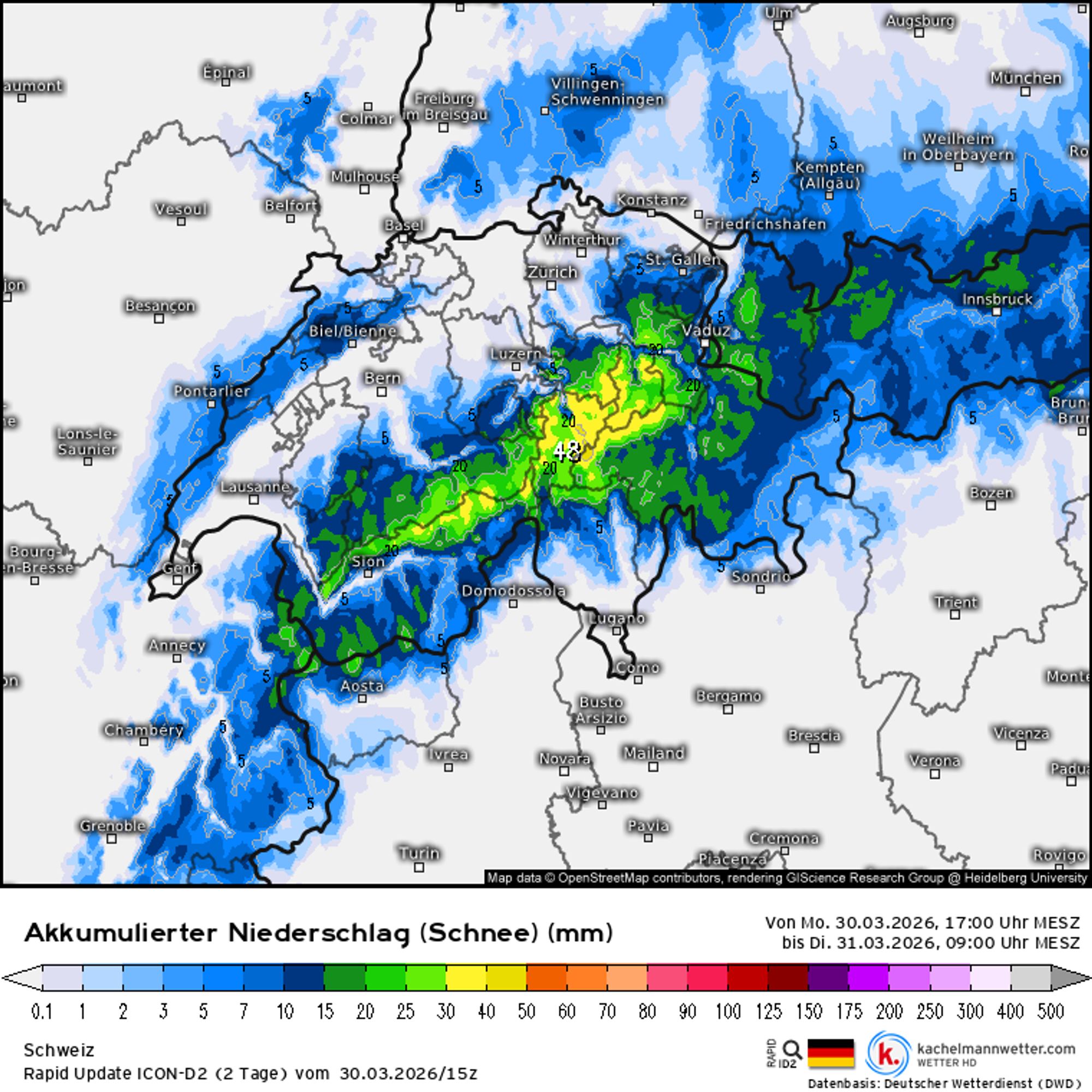
Total amounts will therefore increase significantly. Below, I show expected snowfall totals using ICON-D2 maps (Monday 17:00 to Wednesday 17:00, note that earlier snowfall is not included here). These generally align well with what Coen outlined yesterday, though I should add that the core of the snowfall is really over Switzerland, with somewhat lower amounts expected further east.
In Switzerland, on top of the 20-30 cm already fallen, I expect another 50-80 cm from the Bernese main ridge to the Glarus Alps. In the French Northern Alps, it will mostly remain a light fresh layer of 5-10 cm, with somewhat higher amounts around the Mont Blanc massif. In Austria, in addition to the 10-20 cm already fallen, the deepest conditions are expected in Vorarlberg with another 20-40 cm and local peaks. Other typical Nordstau regions in Austria should also do well with 20-30 cm, but inner-alpine regions should not expect a major dump (especially areas like the Ötztal Alps).
Fortunately, the snow often falls on a solid base from last week’s precipitation, meaning it doesn’t take much to fully enjoy conditions. From an avalanche perspective, caution is still required. Check the avalanche bulletins here.
Locally even more?
In general, these amounts could end up somewhat higher. Why? Not only due to the strength of the northerly stau, but also because of the cold. The snow is fluffier, meaning that the same modeled precipitation (in mm) can translate into more centimeters of snow. Coen explained this yesterday, so if you missed it, check it here.
What’s next?
On Wednesday, the Nordstau weakens completely and snowfall comes to an end. Some clear spells are already possible, but from Thursday onward the sun increasingly appears over the northern Alps. Wednesday will still be fairly cold, but the cold air mass gradually dissipates and temperatures rise steadily toward the end of the week. From the weekend onward, a high-pressure system takes full control, bringing much milder conditions. Temperatures rise significantly, and the 20°C mark comes back into view for many valleys, especially when the southern föhn provides an extra boost early next week.