
For the time being, there is no sign of significant snowfall, but the stabilisation now setting in will bring excellent ski touring conditions over the coming week. The dumps of recent weeks have also laid down a solid base for freeriding in the high alpine. Finding powder is becoming increasingly difficult, however, as temperatures are set to rise sharply. Even so, there are a few caveats. Today we take a look at which regions may be locally less favourable and cast an eye over the long‑term outlook: does April have a surprise in store?

High‑pressure system continues to expand northwards
During the Easter period, the Alps lie under a Mediterranean high‑pressure system with a ridge extending into Central Europe. Northern and north‑western Europe remain wet and unsettled. On Monday, a touch of that unsettled weather spills into the Northern Alps, the first caveat. Cloud cover will increase especially north of the main Alpine ridge, and the freezing level will drop somewhat.
After that, the high extends a ridge towards the polar regions. Over Eastern Europe, cold air then flows southwards. In Western Europe, however, the flow turns southerly, bringing warm conditions that will be most noticeable in the Western Alps. Later in the week, the eastern half of the Alps may come under the influence of somewhat cooler air from the north.

- -20°
- -15°
- -10°
- -5°
- 0°
- 5°
- 10°
- 15°
- 20°
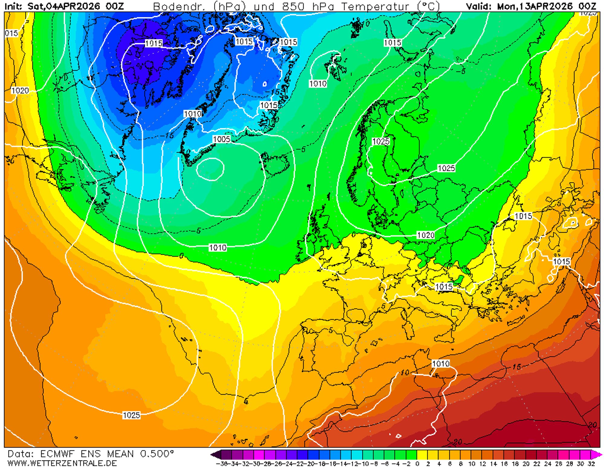
The evolution of upper‑air temperatures over the coming days
Clear skies in the western half
Those heading into the Swiss and French Alps, or the western half of Northern Italy, can count on sunny and settled weather through at least Thursday. Clear nights will result in firm snow early in the morning. As the day progresses, east‑ and southeast‑facing slopes soften first, followed by south‑facing slopes. In the afternoon, west‑facing slopes will also soften.
The last remaining pockets of powder can still be found in north‑facing couloirs which - provided avalanche conditions allow - can offer enjoyment for quite some time. The coming days will be mild, with the freezing level rising to between 2400 and 2900 metres in the afternoon. On Tuesday and Wednesday, another surge of warm air will reach the Alps from the south, with positive temperatures expected up to well above 3000 metres.
More clouds in the east
Especially in Austria, the coming days will be less sunny than elsewhere. This Saturday there may even be an isolated shower, though without any significant precipitation totals. The southern side of the eastern Alps will see more sunshine but slightly cooler conditions than in the Western Alps. Sunday could well be the mildest day here, with the freezing level rising to around 3000 metres. The second warm surge from Tuesday onwards is still uncertain in this region, as cooler air over Eastern Europe remains close by.
Long‑term outlook: Scandinavian high and cooler weather
After the warmth peaks, weather models tend towards a more continental pattern from Friday onwards. A strong high‑pressure system over Scandinavia may develop a ridge extending towards Siberia, while low pressure is likely over the Iberian Peninsula. This increases the likelihood of an easterly flow.
In April, an easterly flow usually brings extended sunny periods, though the south‑western Alps in particular are sensitive to disturbances tracking along the southern flank. If the easterly pattern persists long enough, Austria could also be affected by disturbances arriving from the east. This could potentially lead to increased cloud cover and some light precipitation next weekend.
All in all, not a bad development for the late season: the risk of warm weather decreases, while the chance of rain remains low. Although the ensemble mean temperature settles around climatological norms, there is still considerable uncertainty within the ensembles. From 9 April onwards, upper‑air temperatures fan out wildly = ranging from late‑winter cold to full‑blown spring.